Trail On foot Anhée - Mai 40 - Photo

Randonnées du CGT GUIDE+

© OpenStreetMap contributors
Length
Length
12.3 km
Max alt
Max alt
246 m
Uphill gradient
Uphill gradient
223 m
Km-Effort
Km-Effort  
15.3 km
Min alt
Min alt
84 m
Downhill gradient
Downhill gradient
224 m
Boucle
Boucle
Yes
Creation date :
2022-02-08 11:32:09.275
Updated on :
2022-02-21 10:13:29.315

(0 Reviews)

On foot
On foot
3h28
Difficulty : Easy

Scan this QR Code to open this trail in the SityTrail application

FREE GPS app for hiking

Logo SityTrail SityTrail

IGN / Geographical institutes

Download SityTrail from the App Store Download SityTrail from Google Play

Logo SityTrail SityTrail World

The world is yours!

Download SityTrail from the App Store Download SityTrail from Google Play Download SityTrail on Huawei AppGallery

About

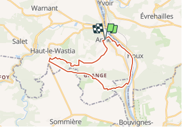
Trail On foot of 12.3 km to be discovered at Wallonia, Namur, Anhée. This trail is proposed by Commissariat général au Tourisme.

Description

Trail created by Vallée de la Meuse Namur-Dinant.


Cross the main road under the protection of the traffic lights. Turn into rue Ribot, then right into rue Petit, which is extended by rue des Fusillés. At the crossroads, turn right into rue Ste Barbe, cross the main road and continue along the path opposite which leads you to the old Dinant-Tamines railway line. Follow this line to the left. Cross the main road. Join the junction with the Dinant-Namur line near the Houx bridge defended in 40 by the Ardennes hunters, whose fortress remains. At the point of the island, take the path on the right towards the houses, extended by the rue du Caillou. Just before the railroad, turn left into the rue de l'écluse which leads you close to the place where the Germans crossed the Meuse. Join the towpath. After 500 meters, pass under the railroad by the pedestrian tunnel. Cross the main road and take the path on the right of the rock near the inn of Bouvignes. This path, ravined by a torrent, was used by the invaders.


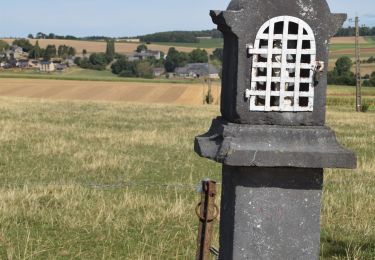
After 1Km, take the path on the right to join the farms of Granges. Note the commemorative plaque. Go down to the right towards Senenne. Note the old tombstones. After the potale in the wall, continue down 200m and take the path on the left leading to the sports complex. Take the railroad to the left. Near the train station, turn right towards the starting point.


Elevation profile

Photos

Positioning

Country:
Belgium
Region :
Wallonia
Department/Province :
Namur
Municipality :
Anhée
Location:
Unknown
Start:(UTM)
633688 ; 5574773 (31U) N.

Trails nearby

Trail Walking Yvoir - RB-Na-21-Terres seigneuriales et carrières de la vallée du Bocq - Photo
Walking
PRO

Walking

Very difficult
(6)
Yvoir, Wallonia, Namur, Belgium
22 km | 30 km-effort
6h 51min
Yes
Trail Walking Yvoir - RB-Na-03 Forteresses, citadelle et abbaye mosanes - Photo
Walking
PRO

Walking

Difficult
(10)
Yvoir, Wallonia, Namur, Belgium
22 km | 30 km-effort
7h 1min
Yes
Trail Walking Yvoir - GG2-Na-38_Godinne-Dinant (2021-11-04) - Photo
Walking
PRO

Walking

Very difficult
(6)
Yvoir, Wallonia, Namur, Belgium
19.5 km | 27 km-effort
6h 13min
No
Trail Walking Anhée - RF-Na-05 Annevoie, côté Jardins_Grande-boucle - Photo
Walking
PRO

Walking

Medium
(11)
Anhée, Wallonia, Namur, Belgium
11.3 km | 14.5 km-effort
3h 6min
Yes
Trail Walking Anhée - RF-Na-05 Annevoie, côté Jardins_Petite-boucle - Photo
Walking
PRO

Walking

Easy
(7)
Anhée, Wallonia, Namur, Belgium
7.4 km | 10 km-effort
2h 7min
Yes
Trail Walking Onhaye - RB-Na-C2-Sommière-Complet_20,4km - Photo
Walking
PRO

Walking

Very difficult
(2)
Onhaye, Wallonia, Namur, Belgium
20 km | 25 km-effort
5h 25min
Yes
Trail Walking Yvoir - RB-Na-21-raccourci-Terres seigneuriales et carrières de la vallée du Bocq - Photo
Walking
PRO

Walking

Very difficult
(2)
Yvoir, Wallonia, Namur, Belgium
18.6 km | 25 km-effort
5h 43min
Yes
Trail Walking Yvoir - D'Yvoir à Evrehailles - Photo
Walking
GUIDE
Desrumaux

Walking

Easy
(2)
Yvoir, Wallonia, Namur, Belgium
9.9 km | 13.2 km-effort
2h 51min
Yes
Trail Walking Yvoir - De Godinne à Rivière par le point de vue des 7 Meuses - Photo
Walking
GUIDE
Desrumaux

Walking

Easy
(5)
Yvoir, Wallonia, Namur, Belgium
8.5 km | 11.6 km-effort
2h 30min
Yes


Close
My subscriptions