Trail On foot Anhée - Serinvaux et Montaigle - Photo

Serinvaux et Montaigle

Randonnées du CGT GUIDE+

© OpenStreetMap contributors
Length
Length
14.3 km
Max alt
Max alt
247 m
Uphill gradient
Uphill gradient
316 m
Km-Effort
Km-Effort  
18.6 km
Min alt
Min alt
89 m
Downhill gradient
Downhill gradient
316 m
Boucle
Boucle
Yes
Creation date :
2022-02-08 11:32:07.95
Updated on :
2022-02-21 10:13:28.677

(0 Reviews)

On foot
On foot
4h13
Difficulty : Easy

Scan this QR Code to open this trail in the SityTrail application

FREE GPS app for hiking

Logo SityTrail SityTrail

IGN / Geographical institutes

Download SityTrail from the App Store Download SityTrail from Google Play

Logo SityTrail SityTrail World

The world is yours!

Download SityTrail from the App Store Download SityTrail from Google Play Download SityTrail on Huawei AppGallery

About

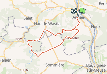
Trail On foot of 14.3 km to be discovered at Wallonia, Namur, Anhée. This trail is proposed by Commissariat général au Tourisme.

Description

Trail created by Vallée de la Meuse Namur-Dinant.


Departure : Place communale d'Anhée.


Take the street on the right of the Maison Communale, pass by the railroad and turn left into the rue des Maquisards. Continue straight ahead towards the schools. Before the schools, continue the path along the chapel of the guardian angel. At the next crossroads, after the small wood, continue straight ahead to reach the Potale Saint Antoine. Turn left to go along the wood, ignore the first path on the right at the corner of the wood and take the next one on the left. At the end of the wood, join a gravel road that you follow to the right to reach the French Memorial of Haut-le-Wastia. At the back of the memorial, take the path on the left towards the isolated house, enter the Bois de Foy. After the bend in the road, leave the stone path and take the path on the right that goes down to the Floyon near the Ruins of Montaigle which you can visit. Turn left to go up the Floyon, past the caves (including the Nutons) and the rock face and reach the Montaigle farm. Continue towards the modern castle of Montaigle and there turn left towards Les Ormes. At the Del Marmol monument, go straight on towards Hontoir and then through fields and woods, join the gravel road that you take to the right to reach the farms of Grange. Go down to the left on the tarmac towards Senenne. Continue straight on for 200m, then take the path on the left which passes over the Ry du Mazy and reaches the sports complex. There, take the railroad to the left to reach your starting point.


Elevation profile

Photos

Positioning

Country:
Belgium
Region :
Wallonia
Department/Province :
Namur
Municipality :
Anhée
Location:
Unknown
Start:(UTM)
633691 ; 5574773 (31U) N.

Trails nearby

Trail Walking Yvoir - RB-Na-21-Terres seigneuriales et carrières de la vallée du Bocq - Photo
Walking
PRO

Walking

Very difficult
(6)
Yvoir, Wallonia, Namur, Belgium
22 km | 30 km-effort
6h 51min
Yes
Trail Walking Yvoir - RB-Na-03 Forteresses, citadelle et abbaye mosanes - Photo
Walking
PRO

Walking

Difficult
(10)
Yvoir, Wallonia, Namur, Belgium
22 km | 30 km-effort
7h 1min
Yes
Trail Walking Yvoir - GG2-Na-38_Godinne-Dinant (2021-11-04) - Photo
Walking
PRO

Walking

Very difficult
(6)
Yvoir, Wallonia, Namur, Belgium
19.5 km | 27 km-effort
6h 13min
No
Trail Walking Anhée - RF-Na-05 Annevoie, côté Jardins_Grande-boucle - Photo
Walking
PRO

Walking

Medium
(11)
Anhée, Wallonia, Namur, Belgium
11.3 km | 14.5 km-effort
3h 6min
Yes
Trail Walking Anhée - RF-Na-05 Annevoie, côté Jardins_Petite-boucle - Photo
Walking
PRO

Walking

Easy
(7)
Anhée, Wallonia, Namur, Belgium
7.4 km | 10 km-effort
2h 7min
Yes
Trail Walking Onhaye - RB-Na-C2-Sommière-Complet_20,4km - Photo
Walking
PRO

Walking

Very difficult
(2)
Onhaye, Wallonia, Namur, Belgium
20 km | 25 km-effort
5h 25min
Yes
Trail Walking Yvoir - RB-Na-21-raccourci-Terres seigneuriales et carrières de la vallée du Bocq - Photo
Walking
PRO

Walking

Very difficult
(2)
Yvoir, Wallonia, Namur, Belgium
18.6 km | 25 km-effort
5h 43min
Yes
Trail Walking Yvoir - D'Yvoir à Evrehailles - Photo
Walking
GUIDE
Desrumaux

Walking

Easy
(2)
Yvoir, Wallonia, Namur, Belgium
9.9 km | 13.2 km-effort
2h 51min
Yes
Trail Walking Yvoir - De Godinne à Rivière par le point de vue des 7 Meuses - Photo
Walking
GUIDE
Desrumaux

Walking

Easy
(5)
Yvoir, Wallonia, Namur, Belgium
8.5 km | 11.6 km-effort
2h 30min
Yes


Close
My subscriptions