Trail On foot Anhée - Panorama du Nord Fays - Photo

Panorama du Nord Fays

Randonnées du CGT GUIDE+

© OpenStreetMap contributors
Length
Length
5.1 km
Max alt
Max alt
243 m
Uphill gradient
Uphill gradient
143 m
Km-Effort
Km-Effort  
7 km
Min alt
Min alt
113 m
Downhill gradient
Downhill gradient
140 m
Boucle
Boucle
Yes
Creation date :
2022-02-08 11:29:14.983
Updated on :
2022-02-21 10:10:28.793

(1 Reviews)

On foot
On foot
1h35
Difficulty : Easy

Scan this QR Code to open this trail in the SityTrail application

FREE GPS app for hiking

Logo SityTrail SityTrail

IGN / Geographical institutes

Download SityTrail from the App Store Download SityTrail from Google Play

Logo SityTrail SityTrail World

The world is yours!

Download SityTrail from the App Store Download SityTrail from Google Play Download SityTrail on Huawei AppGallery

About

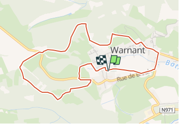
Trail On foot of 5.1 km to be discovered at Wallonia, Namur, Anhée. This trail is proposed by Commissariat général au Tourisme.

Description

Trail created by Vallée de la Meuse Namur-Dinant.


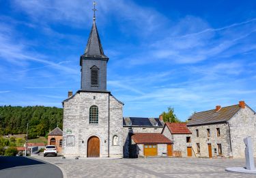
Departure : Place de l'église de Warnant.


Take the path along the cemetery. Continue on the road on the left. At the crossroads of the chapel, turn left. Note the view of the Maison de Pierre farmhouse on your left. After 100m, at the crossroads, turn left into rue du Fond. Turn right into rue Esbrulets. The road curves for 300m. Then take a steep stone path that enters the wood on the right. After 300m, in front of a villa on the right, take the left path. Leave a path that goes down to the left and continue by the chicanes. At the next crossing, go up to the right. At the next T, turn left and reach the panorama of the Nord-Fays. You can see the whole Warnant basin and thus understand its mild microclimate. You are also close to dozens of springs that feed the village. When you arrive near the two lime trees, cross the road and take the path opposite. At the Y, after 300m, turn left and enter the Aujes wood, that is to say the communal toilets. At the Y, after 400m, turn left again and go down a path that becomes a track near the two houses of Plate Pierre. At the road, turn left, then, after 100m, right to go down to the fountain Sainte-Adèle and the chapel ND de Beauraing. At the Union Warnantaise hall, turn right into the rue de la digue and reach the starting point.


Elevation profile

Photos

Positioning

Country:
Belgium
Region :
Wallonia
Department/Province :
Namur
Municipality :
Anhée
Location:
Unknown
Start:(UTM)
630470 ; 5575982 (31U) N.

Comments

Please log in to post a review or rate the element


Trails nearby

Trail Walking Anhée - RB-Na-22-raccourci_Vignobles-et-Jardins-d’eau - Photo
Walking
PRO

Walking

Very difficult
(5)
Anhée, Wallonia, Namur, Belgium
16.7 km | 21 km-effort
4h 52min
Yes
Trail Walking Anhée - RB-Na-22_Vignobles-et-Jardins-d’eau - Photo
Walking
PRO

Walking

Very difficult
(11)
Anhée, Wallonia, Namur, Belgium
19.5 km | 25 km-effort
5h 46min
Yes
Trail Walking Yvoir - RB-Na-21-Terres seigneuriales et carrières de la vallée du Bocq - Photo
Walking
PRO

Walking

Very difficult
(6)
Yvoir, Wallonia, Namur, Belgium
22 km | 30 km-effort
6h 51min
Yes
Trail Walking Anhée - RB-Na-16 - Paysages de la Molignée - Photo
Walking
PRO

Walking

Medium
(16)
Anhée, Wallonia, Namur, Belgium
18.3 km | 24 km-effort
5h 13min
Yes
Trail Walking Yvoir - RB-Na-03 Forteresses, citadelle et abbaye mosanes - Photo
Walking
PRO

Walking

Difficult
(10)
Yvoir, Wallonia, Namur, Belgium
22 km | 30 km-effort
7h 1min
Yes
Trail Walking Yvoir - GG2-Na-38_Godinne-Dinant (2021-11-04) - Photo
Walking
PRO

Walking

Very difficult
(6)
Yvoir, Wallonia, Namur, Belgium
19.5 km | 27 km-effort
6h 13min
No
Trail Walking Anhée - RF-Na-05 Annevoie, côté Jardins_Grande-boucle - Photo
Walking
PRO

Walking

Medium
(11)
Anhée, Wallonia, Namur, Belgium
11.3 km | 14.5 km-effort
3h 6min
Yes
Trail Walking Anhée - RF-Na-05 Annevoie, côté Jardins_Petite-boucle - Photo
Walking
PRO

Walking

Easy
(7)
Anhée, Wallonia, Namur, Belgium
7.4 km | 10 km-effort
2h 7min
Yes
Trail Walking Anhée - RB-Na-16 Raccourci - Paysages de la Molignée - Photo
Walking
PRO

Walking

Easy
(15)
Anhée, Wallonia, Namur, Belgium
13 km | 16.6 km-effort
3h 40min
Yes


Close
My subscriptions