Trail On foot Walcourt - Berzée-Thy : d'un château à l'autre - Photo

Berzée-Thy : d'un château à l'autre

Randonnées du CGT GUIDE+

© OpenStreetMap contributors
Length
Length
5.8 km
Max alt
Max alt
179 m
Uphill gradient
Uphill gradient
86 m
Km-Effort
Km-Effort  
6.9 km
Min alt
Min alt
147 m
Downhill gradient
Downhill gradient
84 m
Boucle
Boucle
Yes
Creation date :
2022-02-08 11:29:07.344
Updated on :
2022-02-21 10:10:20.357

(0 Reviews)

On foot
On foot
1h34
Difficulty : Easy

Scan this QR Code to open this trail in the SityTrail application

FREE GPS app for hiking

Logo SityTrail SityTrail

IGN / Geographical institutes

Download SityTrail from the App Store Download SityTrail from Google Play

Logo SityTrail SityTrail World

The world is yours!

Download SityTrail from the App Store Download SityTrail from Google Play Download SityTrail on Huawei AppGallery

About

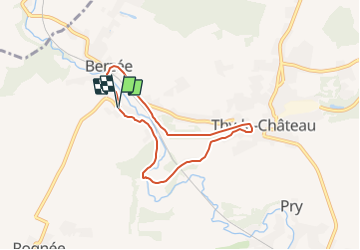
Trail On foot of 5.8 km to be discovered at Wallonia, Namur, Walcourt. This trail is proposed by Commissariat général au Tourisme.

Description

Trail created by Pays des Lacs.


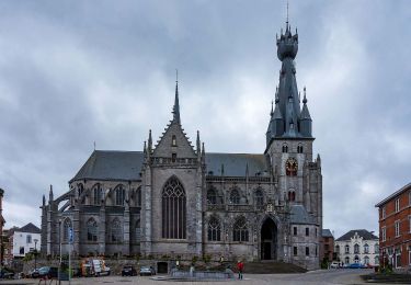
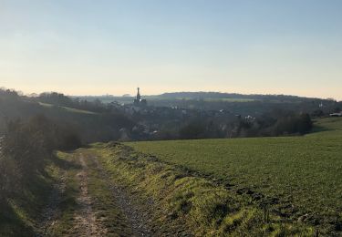
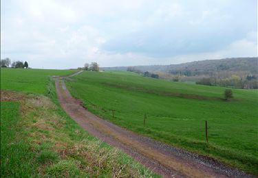
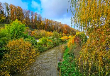
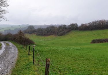
This walk follows a portion of the RAVeL network and runs along the Thyria river and then the Eau d’Heure to connect the two villages. The fortified castle of Berzée – the oldest remains of which date back to the 13th or 14th century – was transformed into a stately residence by Charles de Namur at the beginning of the 17th century. After four generations, the Trazegnies family took up residence there and gave it its name. The first traces of the Château de Thy-le-Château date back to the 12th century. However, it has been destroyed numerous times throughout history. Notably, it was burned down by the Sans-Culottes in 1790 and remained in ruins for years. In 1896, it became a brewery until 1919. From 1928 to 1931, the castle was completely restored. In 1940, the explosion of a munitions convoy severely damaged the castle once more. It has since been rebuilt.


Elevation profile

Photos

Positioning

Country:
Belgium
Region :
Wallonia
Department/Province :
Namur
Municipality :
Walcourt
Location:
Unknown
Start:(UTM)
599950 ; 5571204 (31U) N.

Trails nearby

Trail Walking Ham-sur-Heure-Nalinnes - Promenade dans le Bois Jacques - Photo
Walking
GUIDE
Desrumaux

Walking

Very easy
(8)
Ham-sur-Heure-Nalinnes, Wallonia, Hainaut, Belgium
3.5 km | 4.7 km-effort
1h 0min
Yes
Trail Walking Walcourt - GG-Na-17_Walcourt - Philippeville - Photo
Walking
PRO

Walking

Very difficult
(2)
Walcourt, Wallonia, Namur, Belgium
21 km | 26 km-effort
5h 9min
No
Trail Walking Ham-sur-Heure-Nalinnes - Balade printanière à Ham-sur-Heure - Photo
Walking
GUIDE
Desrumaux

Walking

Easy
(1)
Ham-sur-Heure-Nalinnes, Wallonia, Hainaut, Belgium
11.5 km | 14.5 km-effort
3h 7min
Yes
Trail Walking Walcourt - Promenade à Chastrès - Photo
Walking
GUIDE
Desrumaux

Walking

Very easy
(1)
Walcourt, Wallonia, Namur, Belgium
4.7 km | 6 km-effort
1h 10min
Yes
Trail Walking Ham-sur-Heure-Nalinnes - Balade en forêt à Ham-sur-Heure - Photo
Walking
GUIDE
Desrumaux

Walking

Medium
(1)
Ham-sur-Heure-Nalinnes, Wallonia, Hainaut, Belgium
9 km | 11 km-effort
2h 23min
Yes
Trail Walking Walcourt - Randonnée autour de Walcourt - Photo
Walking
Michele Vercauteren

Walking

Medium
(2)
Walcourt, Wallonia, Namur, Belgium
16 km | 20 km-effort
3h 43min
Yes
Trail Walking Ham-sur-Heure-Nalinnes - De Ham-sur-Heure à Cour-sur-Heure - Photo
Walking
GUIDE
Desrumaux

Walking

Easy
(1)
Ham-sur-Heure-Nalinnes, Wallonia, Hainaut, Belgium
10 km | 12.2 km-effort
2h 30min
Yes
Trail Walking Ham-sur-Heure-Nalinnes - La promenade du Pré al Rocq - Photo
Walking
GUIDE
Desrumaux

Walking

Medium
Ham-sur-Heure-Nalinnes, Wallonia, Hainaut, Belgium
5.4 km | 7.3 km-effort
1h 40min
Yes
Trail Walking Walcourt - Balade à Walcourt - Photo
Walking
GUIDE
Desrumaux

Walking

Medium
Walcourt, Wallonia, Namur, Belgium
5.9 km | 7.3 km-effort
1h 39min
Yes


Close
My subscriptions