Trail On foot Walcourt - Pays des Splingues - Photo

Pays des Splingues

Randonnées du CGT GUIDE+

© OpenStreetMap contributors
Length
Length
5.4 km
Max alt
Max alt
268 m
Uphill gradient
Uphill gradient
86 m
Km-Effort
Km-Effort  
6.6 km
Min alt
Min alt
204 m
Downhill gradient
Downhill gradient
87 m
Boucle
Boucle
Yes
Creation date :
2022-02-08 11:29:05.628
Updated on :
2022-02-21 10:10:18.215

(0 Reviews)

On foot
On foot
1h29
Difficulty : Easy

Scan this QR Code to open this trail in the SityTrail application

FREE GPS app for hiking

Logo SityTrail SityTrail

IGN / Geographical institutes

Download SityTrail from the App Store Download SityTrail from Google Play

Logo SityTrail SityTrail World

The world is yours!

Download SityTrail from the App Store Download SityTrail from Google Play Download SityTrail on Huawei AppGallery

About

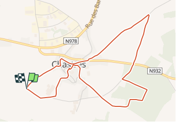
Trail On foot of 5.4 km to be discovered at Wallonia, Namur, Walcourt. This trail is proposed by Commissariat général au Tourisme.

Description

Trail created by Pays des Lacs.


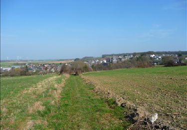
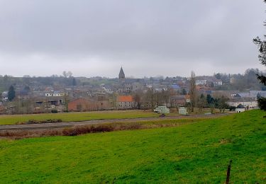
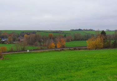
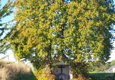
Like many villages in the region, Chastrès was occupied during Roman times. The hub of the Gallo-Roman villa of Gau, the plain extends towards Thy-le-Château and was crossed by the Roman road from Bavay to Trrêves. The walk leads you through fields towards the ‘Notre-Dame des Affligés’ chapel in the hamlet known as ‘les Splingues’. The virgin is invoked against neuralgia and according to tradition, after praying, women use to throw one of their hair pins onto the ground. Another version explains that pins (hence the name Splingues, dialect for ‘épingle’ or pin in French) were thrown by young girls in the hopes of marrying within the year. This peak offers a nice viewpoint over the region. The walk continues towards a grotto, which is dedicated to Our Lady of Lourdes. It is located in a park and is 13 metres deep and 11 metres wide.


Elevation profile

Photos

Positioning

Country:
Belgium
Region :
Wallonia
Department/Province :
Namur
Municipality :
Walcourt
Location:
Unknown
Start:(UTM)
603459 ; 5568810 (31U) N.

Trails nearby

Trail Walking Walcourt - GG-Na-17_Walcourt - Philippeville - Photo
Walking
PRO

Walking

Very difficult
(2)
Walcourt, Wallonia, Namur, Belgium
21 km | 26 km-effort
5h 9min
No
Trail Walking Walcourt - Promenade à Chastrès - Photo
Walking
GUIDE
Desrumaux

Walking

Very easy
(1)
Walcourt, Wallonia, Namur, Belgium
4.7 km | 6 km-effort
1h 10min
Yes
Trail Walking Walcourt - De Laneffe à Fraire par bois et campagnes - Photo
Walking
GUIDE
Desrumaux

Walking

Easy
(1)
Walcourt, Wallonia, Namur, Belgium
12.9 km | 15.5 km-effort
3h 0min
Yes
Trail Walking Walcourt - Randonnée autour de Walcourt - Photo
Walking
Michele Vercauteren

Walking

Medium
(2)
Walcourt, Wallonia, Namur, Belgium
16 km | 20 km-effort
3h 43min
Yes
Trail Walking Walcourt - Balade à Walcourt - Photo
Walking
GUIDE
Desrumaux

Walking

Medium
Walcourt, Wallonia, Namur, Belgium
5.9 km | 7.3 km-effort
1h 39min
Yes
Trail Walking Walcourt - Balade à Yves-Gomezée - Walcourt - Photo
Walking
GUIDE
Desrumaux

Walking

Difficult
Walcourt, Wallonia, Namur, Belgium
10.8 km | 13.2 km-effort
2h 59min
Yes
Trail Walking Ham-sur-Heure-Nalinnes - Balade à Cours-sur-Heure - Photo
Walking
GUIDE
Desrumaux

Walking

Difficult
(1)
Ham-sur-Heure-Nalinnes, Wallonia, Hainaut, Belgium
10.1 km | 13.3 km-effort
3h 44min
Yes
Trail Walking Walcourt - Balade à Berzée - Walcourt - Photo
Walking
GUIDE
Desrumaux

Walking

Medium
Walcourt, Wallonia, Namur, Belgium
8.4 km | 10.4 km-effort
2h 21min
Yes
Trail Mountain bike Walcourt - activity_8994564839 - Photo
Mountain bike
GUIDE
pascalou73

Mountain bike

Very difficult
Walcourt, Wallonia, Namur, Belgium
48 km | 59 km-effort
4h 6min
Yes


Close
My subscriptions