Trail On foot Andenne - Fond des Vaux - Photo

Fond des Vaux

Randonnées du CGT GUIDE+

© OpenStreetMap contributors
Length
Length
3.6 km
Max alt
Max alt
218 m
Uphill gradient
Uphill gradient
88 m
Km-Effort
Km-Effort  
4.7 km
Min alt
Min alt
134 m
Downhill gradient
Downhill gradient
87 m
Boucle
Boucle
Yes
Creation date :
2022-02-08 11:21:20.696
Updated on :
2022-02-21 10:02:22.482

(0 Reviews)

On foot
On foot
1h04
Difficulty : Easy

Scan this QR Code to open this trail in the SityTrail application

FREE GPS app for hiking

Logo SityTrail SityTrail

IGN / Geographical institutes

Download SityTrail from the App Store Download SityTrail from Google Play

Logo SityTrail SityTrail World

The world is yours!

Download SityTrail from the App Store Download SityTrail from Google Play Download SityTrail on Huawei AppGallery

About

Trail On foot of 3.6 km to be discovered at Wallonia, Namur, Andenne. This trail is proposed by Commissariat général au Tourisme.

Description

Trail created by Vallée de la Meuse Namur-Dinant.


This 6.5km walk takes you to discover the village of Sclayn and its countryside.


Your walk starts at the edge of the Meuse and quickly takes you to the heart of the village. You can observe the narrow streets of Sclayn and their stone houses. Just after the Place du Village and its war memorial, you cross the road and come across the beautiful Saint-Maurice de Sclayn church, one of the 5 Romanesque churches of Andenne. Behind the church, a steep path leads you to the Bois de Foresse. You then arrive near the Marchempré quarry. The site is closed and secured, but you can still enjoy magnificent views of the rocks and the pond all along the way. Through the fields, you reach the hamlet of Bruyère in Bonneville. You take a few small streets before going up to the Bois de Friet. A nice path takes you to the place called Fond des Vaux that you cross before returning to your starting point by the small streets. At the end of your walk, don't miss a visit to the archaeological center of the Scladina cave, the only archaeological site that can be visited while it is still being excavated!


Elevation profile

Photos

Positioning

Country:
Belgium
Region :
Wallonia
Department/Province :
Namur
Municipality :
Andenne
Location:
Unknown
Start:(UTM)
640814 ; 5591680 (31U) N.

Trails nearby

Trail Walking Gesves - RB-Na-01 Raccourci - Vallée du Samson en Condroz namurois - Photo
Walking
PRO

Walking

Very difficult
(12)
Gesves, Wallonia, Namur, Belgium
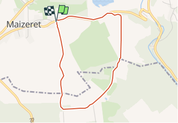
18.3 km | 25 km-effort
5h 34min
Yes
Trail Walking Gesves - RB-Na-01 Vallée du Samson en Condroz namurois - Photo
Walking
PRO

Walking

Very difficult
(15)
Gesves, Wallonia, Namur, Belgium
25 km | 33 km-effort
7h 26min
Yes
Trail Walking Andenne - GESVES- Goyet- n°08- Eau - Photo
Walking
PRO

Walking

Difficult
(9)
Andenne, Wallonia, Namur, Belgium
9.1 km | 12.3 km-effort
2h 36min
Yes
Trail Walking Gesves - GESVES -Mozet- N°06- Biodiversité - Photo
Walking
PRO

Walking

Easy
(10)
Gesves, Wallonia, Namur, Belgium
6.3 km | 7.8 km-effort
1h 41min
Yes
Trail Walking Andenne - La Vadrouille des Castors - Photo
Walking
GUIDE+

Walking

Easy
(5)
Andenne, Wallonia, Namur, Belgium
3.6 km | 4.8 km-effort
1h 0min
Yes
Trail Walking Gesves - RF-Na-03-Goyet_Grande-boucle - Photo
Walking
PRO

Walking

Medium
(5)
Gesves, Wallonia, Namur, Belgium
6.4 km | 8.9 km-effort
1h 54min
Yes
Trail Walking Namur - De Naninne vers Dave par les Fonds de Lustin et les Bois d'Acremont - Photo
Walking
GUIDE
Desrumaux

Walking

Medium
(5)
Namur, Wallonia, Namur, Belgium
19 km | 25 km-effort
5h 0min
Yes
Trail Walking Namur - 2021-10-21_17h46m31_1499 - Photo
Walking
GUIDE
mumu.larandonneuse

Walking

Difficult
(2)
Namur, Wallonia, Namur, Belgium
14.2 km | 19.5 km-effort
4h 25min
Yes
Trail Walking Namur - De Boninne aux Rochers de Marche-les-Dames - Photo
Walking
GUIDE
Desrumaux

Walking

Easy
(1)
Namur, Wallonia, Namur, Belgium
10.8 km | 14.6 km-effort
3h 5min
Yes


Close
My subscriptions