Trail Walking Stavelot - Promenade de l’écureuil - Photo

Promenade de l’écureuil

« L’heure de la fin des découvertes ne sonne jamais. » Colette GUIDE+

© OpenStreetMap contributors
Length
Length
6.6 km
Max alt
Max alt
526 m
Uphill gradient
Uphill gradient
186 m
Km-Effort
Km-Effort  
9.1 km
Min alt
Min alt
369 m
Downhill gradient
Downhill gradient
191 m
Boucle
Boucle
Yes
Creation date :
2022-01-09 19:23:02.778
Updated on :
2022-01-20 10:07:54.969

(0 Reviews)

Walking
Walking
2h03
Difficulty : Medium

Scan this QR Code to open this trail in the SityTrail application

FREE GPS app for hiking

Logo SityTrail SityTrail

IGN / Geographical institutes

Download SityTrail from the App Store Download SityTrail from Google Play

Logo SityTrail SityTrail World

The world is yours!

Download SityTrail from the App Store Download SityTrail from Google Play Download SityTrail on Huawei AppGallery

About

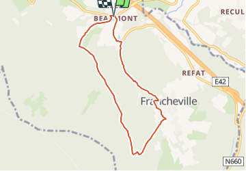
Trail Walking of 6.6 km to be discovered at Wallonia, Liège, Stavelot. This trail is proposed by Au fil de nos découvertes.

Description

🅿️ Départ et Parking:
Beaumont, 7
4970 Stavelot

⚠️ Les chemins sont parfois boueux.
(Mais des alternatives sont faisables de temps en temps sur des chemins secs)

▶️ Suivre la balise : rectangle bleu

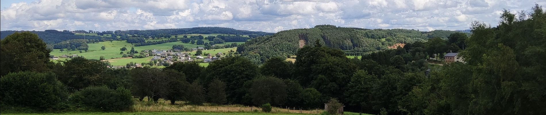
C’est au départ de Beaumont que vous commencerez la promenade, et ce, avec une jolie grimpette.
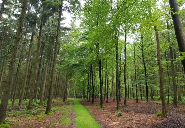
Vous rejoindrez la forêt, que vous traverserez durant quelques kilomètres.
Vous passerez par la réserve naturelle du Noir Ru.
La fin de la promenade est assez technique, car c’est une grande descente dans des cailloux. Mais c’est très joli, car vous longerez un cours d’eau.

Chiens autorisés en laisse. 🐩🐶🐕
Convient pour les enfants . 👱👱‍♂️
Ne convient pas pour les poussettes et personnes à mobilité réduite. 👨‍🦽👩‍🦽👶

N'hésitez pas à aller faire un tour sur notre site internet et nos réseaux :
www.aufildenosdecouvertes.com
www.facebook.com/aufildenosdecouvertes
https://www.instagram.com/au_fil_de_nos_decouvertes/

Elevation profile

Photos

Positioning

Country:
Belgium
Region :
Wallonia
Department/Province :
Liège
Municipality :
Stavelot
Location:
Unknown
Start:(UTM)
712924 ; 5585202 (31U) N.

Trails nearby

Trail Walking Trois-Ponts - Logbiermé. Natura 2000, des sites qui valent le détour ! Lg5 - Photo
Walking
GUIDE+

Walking

Easy
(9)
Trois-Ponts, Wallonia, Liège, Belgium
8.4 km | 10.9 km-effort
Unknown
Yes
Trail Walking Stavelot - 2021-06-30_12h14m27_stavelot_13km_new - Photo
Walking
GUIDE
mumu.larandonneuse

Walking

Medium
(2)
Stavelot, Wallonia, Liège, Belgium
13.4 km | 19.8 km-effort
4h 30min
Yes
Trail Walking Saint Vith - 2021-05-17_18h38m48_recht - Photo
Walking
GUIDE
mumu.larandonneuse

Walking

Easy
(1)
Saint Vith, Wallonia, Liège, Belgium
13.3 km | 17.8 km-effort
4h 2min
Yes
Trail Walking Malmedy - RB-LG-09 - Sur les hauteurs dominant la haute vallée de l’Amblève et la Warche - Photo
Walking
PRO

Walking

Medium
(4)
Malmedy, Wallonia, Liège, Belgium
26 km | 34 km-effort
7h 12min
Yes
Trail Walking Stavelot - Chemin des Sources |stage 3 STAVELOT - HOCKAI - Photo
Walking
PRO

Walking

Very difficult
(1)
Stavelot, Wallonia, Liège, Belgium
19 km | 25 km-effort
5h 45min
No
Trail On foot Malmedy - Brasserie de Bellevaux - Photo
On foot
PRO

On foot

Easy
(3)
Malmedy, Wallonia, Liège, Belgium
10.2 km | 13.1 km-effort
4h 0min
Yes
Trail Trail Stavelot - Extratrail - Stavelot (red) 23km - Photo
Trail
PRO

Trail

Very difficult
(1)
Stavelot, Wallonia, Liège, Belgium
23 km | 35 km-effort
Unknown
Yes
Trail Trail Stavelot - Extra Trail - Stavelot (blue) 13km - Photo
Trail
PRO

Trail

Difficult
(1)
Stavelot, Wallonia, Liège, Belgium
13.4 km | 19.5 km-effort
Unknown
Yes
Trail Trail Stavelot - Extratrail - Stavelot (green) 9km - Photo
Trail
PRO

Trail

Medium
(1)
Stavelot, Wallonia, Liège, Belgium
10.1 km | 13.9 km-effort
Unknown
Yes


Close
My subscriptions