Trail Equestrian Andenne - Le Parcours d'El Côre - Photo

Le Parcours d'El Côre

Vivez Explore Meuse GUIDE+

© OpenStreetMap contributors
Length
Length
20 km
Max alt
Max alt
211 m
Uphill gradient
Uphill gradient
361 m
Km-Effort
Km-Effort  
25 km
Min alt
Min alt
84 m
Downhill gradient
Downhill gradient
362 m
Boucle
Boucle
Yes
Creation date :
2014-12-10 00:00:00.0
Updated on :
2014-12-10 00:00:00.0

(0 Reviews)

Equestrian
Equestrian
3h21
Difficulty : Medium

Scan this QR Code to open this trail in the SityTrail application

FREE GPS app for hiking

Logo SityTrail SityTrail

IGN / Geographical institutes

Download SityTrail from the App Store Download SityTrail from Google Play

Logo SityTrail SityTrail World

The world is yours!

Download SityTrail from the App Store Download SityTrail from Google Play Download SityTrail on Huawei AppGallery

About

Trail Equestrian of 20 km to be discovered at Wallonia, Namur, Andenne. This trail is proposed by Maison du Tourisme Explore Meuse.

Elevation profile

Photos

Points of interest

Point of interest Andenne - Ferme de la Vaudaigle - Photo
Maison du Tourisme Explore Meuse
Point of interest Andenne - La ferme de la commanderie - Photo
Maison du Tourisme Explore Meuse
Point of interest Andenne - Eglise Saint-Firmin de Bonneville - Photo
Maison du Tourisme Explore Meuse
Point of interest Andenne - Cense de Jandren - Photo
Maison du Tourisme Explore Meuse
Point of interest Andenne - Château de Bonneville - Photo
Maison du Tourisme Explore Meuse
Point of interest Andenne - Ferme de Dhuy - Photo
Maison du Tourisme Explore Meuse
ANDENNE 
Point of interest Andenne - La Chapelle du Fond del Côre - Photo
Maison du Tourisme Explore Meuse
Point of interest Andenne - La Valée du Samson - Photo
Maison du Tourisme Explore Meuse
Point of interest Andenne - Forteresse de Samson - Photo
Maison du Tourisme Explore Meuse
Point of interest Andenne - Eglise Saint-Remi de Thon-Samson - Photo
Maison du Tourisme Explore Meuse
Point of interest Andenne - Château-ferme de Thon - Photo
Maison du Tourisme Explore Meuse

Positioning

Country:
Belgium
Region :
Wallonia
Department/Province :
Namur
Municipality :
Andenne
Location:
Andenne
Start:(UTM)
647651 ; 5592934 (31U) N.

Trails nearby

Trail Walking Andenne - RB-Na-17-Au pays de Sainte-Begge - Photo
Walking
PRO

Walking

Very difficult
(13)
Andenne, Wallonia, Namur, Belgium
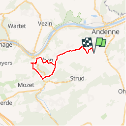
17.8 km | 23 km-effort
5h 18min
Yes
Trail Walking Andenne - Balade dans la Réserve Naturelle de Sclaigneaux - Andenne - Photo
Walking
GUIDE
Desrumaux

Walking

Easy
(5)
Andenne, Wallonia, Namur, Belgium
8.2 km | 11.1 km-effort
2h 24min
Yes
Trail Walking Gesves - RB-Na-01 Raccourci - Vallée du Samson en Condroz namurois - Photo
Walking
PRO

Walking

Very difficult
(12)
Gesves, Wallonia, Namur, Belgium
18.3 km | 25 km-effort
5h 34min
Yes
Trail Walking Gesves - RB-Na-01 Vallée du Samson en Condroz namurois - Photo
Walking
PRO

Walking

Very difficult
(15)
Gesves, Wallonia, Namur, Belgium
25 km | 33 km-effort
7h 26min
Yes
Trail Walking Ohey - OHEY- Haillot- N°12-Bois  - Photo
Walking
PRO

Walking

Easy
(5)
Ohey, Wallonia, Namur, Belgium
6.6 km | 7.9 km-effort
1h 42min
Yes
Trail Walking Andenne - GESVES- Goyet- n°08- Eau - Photo
Walking
PRO

Walking

Difficult
(9)
Andenne, Wallonia, Namur, Belgium
9.1 km | 12.3 km-effort
2h 36min
Yes
Trail Walking Gesves - Sentiers d'art : Boucle 11- Haltinne - Photo
Walking
PRO

Walking

Easy
(6)
Gesves, Wallonia, Namur, Belgium
9.6 km | 11.8 km-effort
2h 0min
Yes
Trail Walking Ohey - Promenade des Petits Ponts- Bois d'Ohey - Photo
Walking
PRO

Walking

Medium
(7)
Ohey, Wallonia, Namur, Belgium
6.2 km | 7.4 km-effort
1h 38min
Yes
Trail Walking Andenne - Promenade Thon-Samson - Photo
Walking
GUIDE+

Walking

Easy
(2)
Andenne, Wallonia, Namur, Belgium
6.5 km | 8.2 km-effort
1h 30min
Yes


Close
My subscriptions